Object Search Record
Images
Metadata
Catalog Number |
1976.1.A200.002 |
Object Name |
Blueprint |
Date |
1897 |
Title/Pattern |
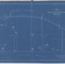
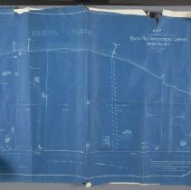
Map of Land Belonging to Ferry Hill Improvement Company |
Artist/Author/Creator |
Latham, J.A. |
Description |
Blueprint of surveyor-type property map showing several lots on the western side of Ferry Lane, in Bristol RI. Dated November 1897. Properties delineated were owned by five different families, including AS Van Wickle and A(rio) Pardee. There is a note that the outline of this map was taken from a map recorded at the Bristol Town Clerk's office in Bristol, RI. That map was recorded in 1887. Ferro Prussiate ink on wove paper. Scale 200 feet per inch. |
Maker's Information |
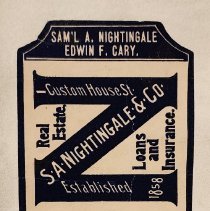
Adhesive paper label. Black and cream. SAM'L A. NIGHTINGALE / EDWIN F. CARY. / CUSTOM HOUSE ST. / REAL ESTATE /S. A. NIGHTINGALE & CO / LOANS AND INSURANCE /ESTABLISHED 1858 / LONG DISTANCE TELEPHONE / PROVIDENCE, R. I. |
Materials |
Paper/Ink, Ferro Prussiate (blueprint) |
Condition |
Very Good |
Associated with |
Van Wickle, Augustus Stout Bessie Pardee Van Wickle McKee Pardee, Ario Jr. |
Search Terms |
Blithewold I Landscape Drawing Survey Plan Blueprint Map |
Catalog Sub-category |
Documentary Artifact |